INDIA CLIMATE ATLAS A Web-Based Environmental Intelligence Platform for Weather Monitoring, Climate Awareness and Flood–Landslide Risk Assessment
AUTHOR 1: - PRIYANKA SINGH RAJPUT AUTHOR 2: -RITESH RANGAR DATE: - 15TH AUGUST 2026 ABSTRACT India experiences a wide range of weather and climatic conditions because of its diverse geography. While this diversity is an important environmental characteristic of the country, it also contributes to the occurrence of natural hazards such as floods and landslides in different regions. These events can affect human lives, infrastructure, agriculture, wildlife and the surrounding environment. This research presents India Climate Atlas, a web-based platform developed using HTML, CSS and JavaScript. The main purpose of the project is to bring different types of weather and climate information together in one accessible interface. The platform provides live weather information, hourly forecasts, multi-day forecasts, seasonal information, future temperature projections, rainfall probability visualization, state-wise climate information, flood-risk awareness, landslide-risk awareness and an alert-mode interface. An additional Educational Purpose and Climate Awareness section has been included to help users understand the climatic characteristics of Indian states and the environmental conditions associated with different seasons. The current version of the project is a functional prototype. It uses a Weather API for meteorological information, while the flood and landslide sections provide risk-awareness information rather than claiming to be a fully trained and scientifically validated disaster-prediction system. Future development of the project can incorporate historical disaster records, rainfall intensity, rainfall duration, river discharge, soil moisture, elevation, slope, geological information, satellite observations and machine-learning techniques. The central idea behind this research is not that floods and landslides can be completely prevented. Instead, the project explores how accessible environmental information can contribute to better awareness, preparedness and decision-making. With further development and proper validation, the platform could become a more comprehensive environmental decision-support system for India. Keywords: Weather Monitoring, Environmental Intelligence, Flood Risk, Landslide Risk, Climate Awareness, Disaster Preparedness, Weather API, India Climate Atlas, Machine Learning.
TABLE OF CONTENTS
| List of Figures |
| Abstract |
| 1. Introduction |
| 2. Motivation of the project |
| 3. Problem statement |
| 4. Objectives |
| 5. Scope of the project |
| 6. System Overview |
| 7. Technologies Used |
| 8. System Design |
| 9. Data Processing |
| 10. Mathematical Formulation |
| 11. Features Of India Climate Atlas |
| 12. Educational Purpose & Climate Awareness |
| 13. India’s Climatic Diversity & Natural Hazards |
| 14. Real Life Disaster Case Studies |
| 15. Potential Impact on Human Life, Wildlife, and Environment |
| 16. Limitations Of Current Project |
| 17. Future Machine Learning Framework |
| 18. Model Validation |
| 19. Ethical and Safety Considerations |
| 20. Research Contribution |
| 21. Novelty Of the Project |
| 22. Future Scope |
| 23. Conclusion |
| References |
| Appendix A |
| Appendix B |
| Appendix C |
List of Figures
Figure Title
· Figure 1 – India Climate Atlas Main Dashboard
· Figure 2 – Live Weather Interface
· Figure 3 – Hourly Weather Forecast
· Figure 4 – Weekly / Multi Day Forecast
· Figure 5 – Seasonal Climate Information
· Figure 6 – Future Temperature Projection
· Figure 7 – Rainfall Probability Visualization
· Figure 8 – India State-Wise Climate Information
· Figure 9 – Focused State Map
· Figure 10 – Flood-Risk Alert Interface
· Figure 11 – Landslide-Risk Alert Interface
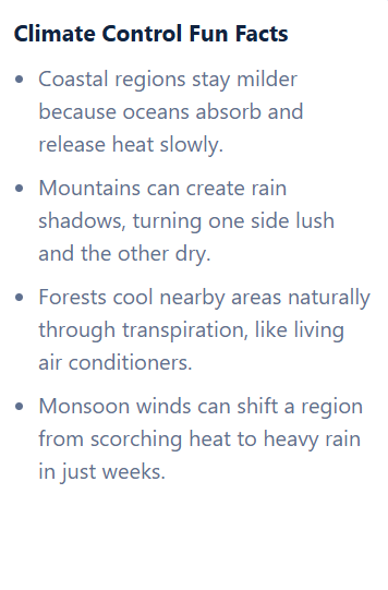
· Figure 12 – Educational Purpose and Climate Awareness
· Figure 13 – Overall System Architecture
· Figure 14 – Proposed Future Machine-Learning Architecture
1. INTRODUCTION
1.1 Background
Weather affects almost every part of daily life. People depend on weather information when travelling, planning agricultural activities, managing water resources and preparing for severe weather conditions.
In India, weather conditions can change considerably from one region to another. The country contains the Himalayan mountains, large river basins, coastal areas, deserts, plateaus, forests and many different climatic zones. Because of this geographical diversity, the same weather condition can have very different consequences in different locations.
For example, heavy rainfall may be beneficial for agriculture in one region, while the same rainfall may increase the possibility of flooding in a low-lying area or contribute to slope instability in a mountainous region.
This observation formed the basis for the development of India Climate Atlas. The project was developed as an attempt to bring weather information and environmental awareness together rather than presenting weather data as isolated numbers.
1.2 Natural Hazards in India
Floods and landslides are among the natural hazards that can significantly affect different parts of India.
Flooding can occur due to intense rainfall, prolonged rainfall, overflowing rivers, poor drainage, coastal conditions and rapid changes in water levels.
Landslides are influenced by heavy or prolonged rainfall, steep slopes, geological conditions, soil characteristics, erosion and changes in vegetation and land use.
This shows why simply knowing the temperature or rainfall probability is not always enough to understand environmental risk.
1.3 Need for Integrated Environmental Information
A conventional weather application may provide:
Temperature + Rainfall + Forecast
A hazard-awareness platform may provide:
Hazard + Warning
The proposed framework combines:
Weather + Climate + Geography + Risk Awareness + Education
The purpose is to transform raw meteorological information into more understandable environmental information.
1.4 Introduction to India Climate Atlas
India Climate Atlas is a browser-based environmental information platform developed to provide an India-focused view of weather and climate conditions.
The platform combines live weather, hourly forecasting, multi-day forecasting, seasonal information, future temperature projection, rainfall-probability visualization, state-wise information, flood-risk awareness, landslide-risk awareness, alert communication and educational climate information.
2. MOTIVATION FOR THE PROJECT
The motivation behind India Climate Atlas came from a simple question:
Can weather information be presented in a way that helps people understand not only what the weather is, but also what the surrounding environmental conditions may mean?
Many weather applications focus primarily on current temperature, rainfall and forecasts. These are useful, but they do not always provide a broader picture of regional climate and environmental risk.
The project therefore attempts to bring weather, climate, geography, risk awareness and education together into one platform.
The objective is not to replace professional disaster-management systems. Instead, it is to provide an accessible technological foundation that can be developed further into a more advanced environmental decision-support system.
3. PROBLEM STATEMENT
Weather information is available through many different platforms, but users may still need to consult multiple sources to understand the relationship between current weather, regional climate and natural-hazard conditions.
The problem addressed by this research is therefore:
How can weather, climate and regional hazard information be integrated into a single web-based platform that improves environmental awareness and provides a foundation for future flood and landslide prediction?
4. OBJECTIVES
The main objective of the project is to develop an India-focused platform that provides weather and climate information while creating awareness about possible environmental risks.
The specific objectives are
- Display live weather conditions.
- Provide hourly weather forecasts.
- Provide multi-day forecasts.
- Display rainfall probability.
- Provide seasonal climate information.
- Provide future temperature projections.
- Provide rainfall visualization.
- Provide state-wise information for India.
- Display flood-risk information.
- Display landslide-risk information.
- Provide an alert-mode interface.
- Provide educational climate information.
- Establish a foundation for future machine-learning-based hazard prediction.
5. SCOPE OF THE PROJECT
The current project focuses mainly on weather monitoring and environmental risk awareness.
The present version includes live weather, hourly forecasting, multi-day forecasting, seasonal information, temperature projections, rainfall probability, rainfall visualization, state-wise information, flood-risk awareness, landslide-risk awareness, alert modes and educational information.
The project can later be extended into a more advanced predictive system by introducing additional environmental datasets and machine-learning models.
6. SYSTEM OVERVIEW
India Climate Atlas is designed as a browser-based application.
The basic process is:
User
↓
India Climate Atlas
↓
Location / State Selection
↓
Weather API / Regional Information
↓
Data Processing
↓
Weather & Climate Information
↓
Risk Awareness
↓
User Understanding and Preparedness
7. TECHNOLOGIES USED
7.1 HTML
HTML is used to create the basic structure of the website.
It defines elements such as:
- headings,
- sections,
- cards,
- buttons,
- maps,
- information panels.
7.2 CSS
CSS is responsible for the visual presentation of the website.
It controls:
- layout,
- spacing,
- typography,
- responsive design,
- cards,
- colours,
- visual hierarchy.
7.3 JavaScript
JavaScript forms the functional part of the application.
It is responsible for:
- retrieving weather information,
- processing data,
- updating the interface,
- responding to user actions,
- displaying forecasts,
- performing calculations.
7.4 Weather API
A Weather API is used to obtain meteorological information.
The API provides the data required for features such as current weather and forecasting.
The use of an API also makes the project dynamic because the displayed weather information can change as new data becomes available.
8. SYSTEM DESIGN
The system can be divided into several logical components.
Weather Module
Provides current weather conditions.
Forecast Module
Provides hourly and multi-day forecasts.
Climate Module
Provides seasonal and state-wise information.
Temperature Projection Module
Provides future temperature projections using the mathematical relationship implemented in the current prototype.
Rainfall Module
Displays precipitation probability and rainfall visualization.
Hazard Awareness Module
Displays flood and landslide risk information.
Educational Module
Provides educational information about Indian states, seasons and climate.
9. DATA PROCESSING
The general data flow is:
The application receives weather information and converts it into readable components for the user.
For example, instead of displaying only a numerical precipitation value, the system can communicate the information through a visual representation.
This approach makes the information easier to interpret for users who may not have a technical background.
10. MATHEMATICAL FORMULATION
The mathematical relationships used in the project are presented below.
Importantly, the equations are separated into current prototype equations and future predictive-model equations.
10.1 Temperature Representation
Temperature is represented as:
T(t)
where represents temperature at a particular time .
10.2 Relative Humidity
Relative humidity is represented as: RH(t)
10.3 Wind Speed
Wind speed is represented as: W(t)
10.4 Precipitation Probability
Precipitation probability is represented as: 0≤P(t)≤100
where represents the probability of precipitation.
10.5 Seasonal Classification
The project categorizes the major seasons using:
S(m)=⎩⎨⎧Summer,Monsoon,Post-Monsoon,Winter,3≤m≤56≤m≤910≤m≤1112≤m≤2
Where m represents the month.
10.6 Future Temperature Projection
The current prototype uses:
where: T(y) is the projected temperature, T(b) is the base temperature, O(y) is the predefined projection offset.
10.7 Rainfall Visualization
The rainfall visualization uses:
where:
- P represents precipitation probability,
- I represents the visual intensity used by the interface.
10.8 Flood-Risk Classification
The current system represents flood risk as Low, Moderate or High.
10.9 Landslide-Risk Classification
The current system represents landslide risk as Low, Moderate or High.
10.10 Future Flood Prediction Model
A future version may use rainfall, rainfall intensity, duration, river discharge, soil moisture, elevation and land-use data to estimate flood probability. P(Flood∣X) =f (P,I ,D,Q,S,E,L)
10.11 Future Landslide Prediction Model
A future version may combine rainfall, slope, elevation, geology, vegetation and land-use information to estimate landslide probability. P(Landslide∣X) = f(R,I,D,S,E,G,V,L)
11. FEATURES OF INDIA CLIMATE ATLAS
11.1 Live Weather
Displays the current weather conditions.
11.2 Hourly Forecast
Shows short-term weather changes throughout the day.
11.3 Weekly / Multi-Day Forecast
Provides a broader outlook for upcoming weather.
11.4 Seasonal Information
Explains the major climatic seasons of India.
11.5 Future Temperature Projection
Shows how future temperature trends can be represented within the application.
11.6 Rainfall Visualization
Presents precipitation probability in an easy-to-understand visual form.
11.7 State-Wise Climate Information
Allows users to explore climate information for different Indian states.
11.8 Flood-Risk Awareness
Displays regional flood-risk categories.
11.9 Landslide-Risk Awareness
Displays regional landslide-risk categories.
11.10 Alert Mode
Communicates environmental risk through simple categories such as Low, Moderate and High.
12. EDUCATIONAL PURPOSE AND CLIMATE AWARENESS
The former Fun Facts section has been renamed Educational Purpose and Climate Awareness.
The section provides educational information about:
- Indian states,
- seasons,
- regional climate,
- geographical characteristics,
- environmental conditions.
****
Its purpose is to make the platform useful not only for weather monitoring but also for learning about India's climatic diversity.
****
13. INDIA'S CLIMATIC DIVERSITY AND NATURAL HAZARDS
India's geographical diversity means that environmental risks are not the same everywhere.
Mountainous regions may have greater landslide susceptibility, while low-lying river basins may have greater flood vulnerability.
ENIVRONMENT RISK= HAZRADS+EXPOSURES+VULNERABILITIES
In practical terms, the same rainfall event can produce very different consequences depending on the location.
Therefore, future versions of India Climate Atlas should move toward location-specific risk analysis.
14. REAL-LIFE DISASTER CASE STUDIES
14.1 Uttarakhand Disaster — 2013
The 2013 Uttarakhand disaster was one of the major natural disasters in India's recent history, involving extreme rainfall, floods and landslides.
The event demonstrated the destructive interaction between extreme weather, mountainous terrain and human exposure.
How the proposed system could contribute
A future version of the system could combine:
RAINFALL + RAINFALL DURATION + SLOPE + ELEVATION + HISTORICAL EVENTS
to identify areas requiring closer monitoring.
It would be incorrect to claim that the current website could have prevented the disaster.
However, a properly validated predictive and warning system could potentially have supported:
- earlier awareness,
- route planning,
- monitoring,
- preparedness,
- evacuation decisions.
14. REAL-LIFE DISASTER CASE STUDIES
14.1 Uttarakhand Disaster — 2013
The 2013 Uttarakhand disaster was one of the major natural disasters in India's recent history, involving extreme rainfall, floods and landslides.
The event demonstrated the destructive interaction between extreme weather, mountainous terrain and human exposure.
How the proposed system could contribute
A future version of the system could combine:
RAINFALL + RAINFALL DURATION + SLOPE + ELEVATION + HISTORICAL EVENTS
to identify areas requiring closer monitoring.
It would be incorrect to claim that the current website could have prevented the disaster.
However, a properly validated predictive and warning system could potentially have supported:
- earlier awareness,
- route planning,
- monitoring,
- preparedness,
- evacuation decisions.
14.2 KERALA FLOODS — 2018
The 2018 Kerala floods demonstrated the consequences that prolonged and intense rainfall can have when combined with river systems, terrain and human settlements.
The event provides a useful case study for the proposed flood-risk framework.
A future model could combine:
RAINFALL + RIVER LEVEL + RIVER DISCHAGRE + SOIL MOISTURE + TERRAIN
to estimate flood probability.
Again, the purpose would not be to claim that the disaster could have been completely avoided.
The realistic objective would be to improve the availability of information that supports preparedness.
14.3 HIMACHAL PRADESH FLOODS AND LANDSLIDES — 2023
****
Himachal Pradesh experienced severe rainfall-related floods and landslides during 2023.
The event demonstrates why mountainous areas require more than ordinary weather forecasting.
For landslide prediction, future versions of the platform could combine:
RAINFALL + SLOPE + ELEVATION + GEOLOGY + LAND COVER
This would provide a much stronger foundation than using rainfall alone.
15. POTENTIAL IMPACT ON HUMAN LIFE, WILDLIFE AND ENVIRONMENT
An advanced version of the platform could potentially support:
- public awareness,
- preparedness,
- safer travel decisions,
- infrastructure monitoring,
- agricultural planning,
- wildlife protection,
- environmental monitoring.
The aim is not to guarantee prevention of disasters, but to improve access to information that may support better decisions.
Disasters do not affect only humans.
Floods and landslides can also damage:
- forests,
- wildlife habitats,
- wetlands,
- rivers,
- agricultural ecosystems,
- protected areas.
A future version of the project could therefore include environmental exposure layers.
For example:
ENIVRONMENT EXPOSURE + HAZARD PROBABILITY * AFFECTED ECOSYSTEM AREA
This could help identify areas where a natural hazard overlaps with environmentally sensitive regions.
16.LIMITATIONS OF THE CURRENT PROJECT
A strong research paper should openly discuss its limitations.
The current project has several.
16.1 It is a Prototype
The current application demonstrates the concept and functionality but is not an operational disaster-management system.
16.2 Flood and Landslide Risk Are Not Yet ML Predictions
The current risk information should not be represented as scientifically validated machine-learning predictions.
16.3 Future Temperature Projection Is Deterministic
The temperature projection currently uses a predefined mathematical relationship rather than a climate-model dataset.
16.4 Rainfall Visualization Is Not Professional Radar
The rainfall visualization represents precipitation probability and should not be confused with actual radar reflectivity.
16.5 No Accuracy Claim Is Made
Because the current system does not contain a trained and independently validated flood/landslide prediction model, the research does not report fabricated accuracy percentages.
This is a strength rather than a weakness because it maintains scientific honesty.
Its main limitations are:
- flood and landslide categories are not yet generated by trained machine-learning models,
- future temperature projections are deterministic,
- rainfall visualization is not professional weather radar,
- no statistical accuracy values are claimed,
- additional environmental datasets are required for operational prediction.
Acknowledging these limitations makes the research more transparent and scientifically credible.
17. FUTURE MACHINE-LEARNING FRAMEWORK
Future versions can integrate historical rainfall, temperature, humidity, river levels, soil moisture, elevation, slope, geology, land cover, satellite data and historical disaster records.
These datasets could be processed through machine-learning models to estimate flood and landslide probabilities.
The data could then be used to train predictive models.
Proposed architecture
Historical Data
↓
Data Cleaning
↓
Feature Engineering
↓
Training Dataset
↓
Machine Learning
↓
Flood Model + Landslide Model
↓
Probability Estimation
↓
Risk Classification
↓
Alert Interface
18. MODEL VALIDATION
When predictive models are developed, they should be evaluated using:
- Accuracy (Accuracy=
- Precision (Precision=
- Recall (Recall=
- F1 Score (F1=2 (PRECISION *RECALL / PRECISION + RECALL)
These metrics should only be reported after the models have been trained and tested on appropriate datasets.
No precision or accuracy values are claimed in this research because the current prototype has not undergone this validation process.
19. ETHICAL AND SAFETY CONSIDERATIONS
The platform should clearly distinguish between weather forecasts, risk awareness and official disaster warnings. The system should also communicate that its information is intended for awareness and decision support and should not replace official emergency instructions.
It should not replace instructions issued by government disaster-management authorities. Future versions should also consider data privacy, secure API communication and responsible presentation of risk information.
A disaster-related application must be developed responsibly.
An incorrect warning can create unnecessary panic, while a missed warning can create a false sense of safety.
Therefore, future versions should clearly distinguish between:
Weather Forecast
and
Hazard Prediction
and
Official Disaster Warning
20. RESEARCH CONTRIBUTION
The project contributes:
- a working weather and climate web application,
- integration of weather and hazard awareness,
- an educational climate module,
- a foundation for future machine-learning research.
· The project contributes in four main areas.
Technical Contribution
· A functional HTML/CSS/JavaScript weather and climate interface.
Environmental Contribution
· Integration of weather information with flood and landslide awareness.
Educational Contribution
· State-wise and seasonal climate information through the Educational Purpose and Climate Awareness section.
Research Contribution
· A foundation for future machine-learning-based flood and landslide prediction.
21. NOVELTY OF THE PROJECT
The novelty lies in combining weather, climate, geography, risk awareness and education into a single India-focused platform.
The project does not claim to have invented a new scientific prediction algorithm. Instead, it provides an integrated framework that can be expanded into a more advanced environmental intelligence system.
Its main novelty lies in the integration and presentation of different environmental information components in a single India-focused platform.
WEATHER + CLIMATE + GEOGRAPHY + RISK + EDUCATION
This integrated approach provides a foundation that can later be expanded into a more sophisticated environmental decision-support system.
****
22. FUTURE SCOPE
Future work can include:
Machine Learning
Develop validated flood and landslide prediction models.
GIS
Introduce geographical layers for:
- elevation,
- slope,
- rivers,
- soil,
- geology,
- land use.
Satellite Data
Integrate satellite-derived environmental observations.
Weather Radar
Replace probability visualization with actual radar products where appropriate.
IoT
Connect:
- rainfall sensors,
- river-level sensors,
- soil-moisture sensors.
Mobile Application
Develop an Android/iOS version.
Real-Time Alerts
Provide:
- push notifications,
- SMS,
- email,
- browser notifications.
Cloud Infrastructure
Move the system toward scalable nationwide monitoring.
****
These additions could significantly improve the system's usefulness and research value.
23. CONCLUSION
India Climate Atlas began as a weather and climate web application, but it demonstrates the potential to grow into a broader environmental intelligence platform.
The current version successfully combines live weather, forecasts, seasonal information, temperature projections, rainfall visualization, state-wise climate information, flood-risk awareness, landslide-risk awareness, alerts and educational content.
With the addition of historical datasets, geographical information and validated machine-learning models, India Climate Atlas could eventually develop into an environmental decision-support platform that supports research, education and disaster preparedness across India.
The project does not claim that floods or landslides can be eliminated. Natural hazards are complex events influenced by many environmental and human factors.
Instead, the central idea is that better information can lead to better awareness, and better awareness can contribute to better preparedness.
The current prototype provides the foundation. The next stage would be to introduce historical datasets, GIS layers, satellite observations, hydrological information and machine-learning models.
The long-term vision can therefore be represented as:
DATA->ANALYSIS-> PREDICTION->AWARENESS->PREPAREDNESS->REDUCED POTENTIAL LOSS
THEREFORE
With further development and rigorous validation, India Climate Atlas could evolve from a weather-monitoring website into a broader environmental intelligence and decision-support platform.
Its potential applications could extend beyond individual users to educational institutions, researchers, infrastructure planners, environmental organizations and disaster-management stakeholders.
Most importantly, the project demonstrates how a relatively simple web technology stack can serve as the foundation for a much larger environmental research system.
REFERENCES
- Open-Meteo. Weather Forecast API Documentation. ++Open-Meteo Weather API Documentation++
- Indian Space Research Organisation. Landslide Atlas of India. ++ISRO Landslide Atlas of India++
- Kerala State Disaster Management Authority. Kerala Floods 2018. ++Kerala State Disaster Management Authority++
- Government of India. Uttarakhand Disaster Information. ++Government of India Information Portal++
- Himachal Pradesh State Centre on Climate Change. Climate and Disaster-Related Reports. ++Himachal Pradesh State Centre on Climate Change++
- National Disaster Management Authority, Government of India. SACHET National Disaster Alert Portal. ++SACHET National Disaster Alert Portal++
APPENDIX A — MATHEMATICAL FORMULAE
| Purpose | Formula |
| Temperature | (T(t)) |
| Humidity | (RH(t)) |
| Wind Speed | (W(t)) |
| Precipitation Probability | (0\leq P(t)\leq100) |
| Seasonal Classification | (S(m)) |
| Temperature Projection | (T_y=T_{base}+O_y) |
| Rainfall Visualization | (I=\min(100,\max(10,P))) |
| Future Flood Model | (P(Flood\mid X)=f(P,I,D,Q,S,E,L)) |
| Future Landslide Model | (P(Landslide\mid X)=f(R,I,D,S,E,G,V,L)) |
| Accuracy | (\frac{TP+TN}{TP+TN+FP+FN}) |
| Precision | (\frac{TP}{TP+FP}) |
| Recall | (\frac{TP}{TP+FN}) |
| F1 | (2\frac{Precision\times Recall}{Precision+Recall}) |
APPENDIX B — PROJECT SCREENSHOTS
Figure 1. India Climate Atlas main dashboard.
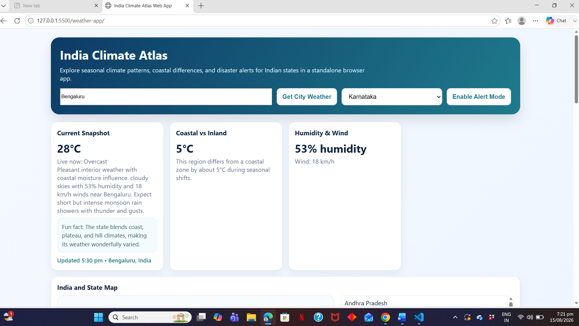
Figure 2 – Live Weather Interface
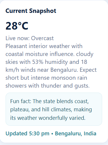
Figure 3 – Hourly Weather Forecast
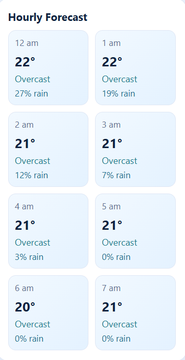
Figure 4 – Multi-day/Weekly Weather Forecast
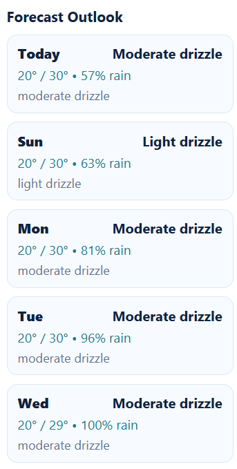
Figure 5– Seasonal Climate Forecast Information
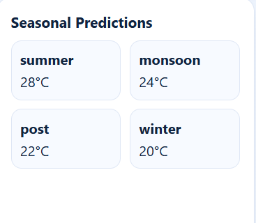
Figure 6– Future Temperature Projection
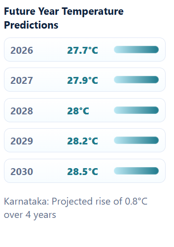
Figure 7– Rainfall Probability Radar
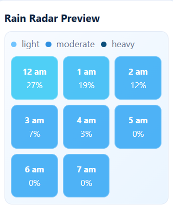
Figure 8– India State Wise Climate Interface
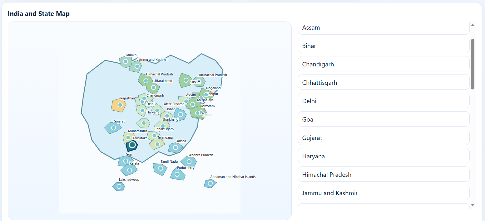
Figure 9– Focused State Map
****
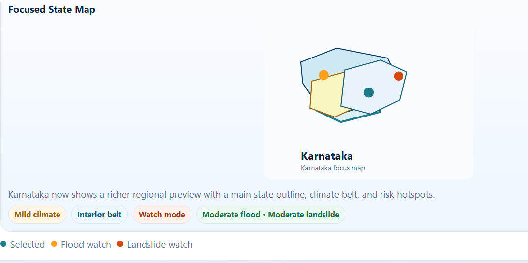
Figure 10– Flood Risk Alert Interface
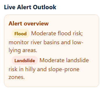
Figure 11–Landslide Risk Alert Interface
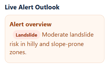
Figure 12–Educational Purpose and Climate Awareness
****
Figure 13–Overall System Architecture
USER
│
▼
┌────────────────────┐
│ INDIA CLIMATE ATLAS│
└─────────┬──────────┘
│
HTML / CSS / JS
│
┌────────────┴────────────┐
▼ ▼
Location Search State Selection
│ │
▼ ▼
Weather API Climate Database
│ │
└────────────┬────────────┘
▼
ENVIRONMENTAL DATA
│
┌────────────────┼────────────────┐
▼ ▼ ▼
Current Forecast Climate
Weather Information Information
│ │ │
└────────────────┼────────────────┘
▼
RISK-AWARENESS LAYER
┌─────┴─────┐
▼ ▼
Flood Landslide
Risk Risk
│ │
└─────┬─────┘
▼
ALERT MODE
│
▼
USER
****
****
****
Figure 14— Proposed Future AI/ML Architecture
HISTORICAL DATA
│
▼
DATA COLLECTION
│
▼
DATA CLEANING
│
▼
FEATURE ENGINEERING
│
▼
ML MODELS
┌──────┴──────┐
▼ ▼
FLOOD LANDSLIDE
MODEL MODEL
│ │
▼ ▼
FLOOD RISK LANDSLIDE RISK
│ │
└──────┬──────┘
▼
RISK ENGINE
│
▼
ALERT SYSTEM
│
▼
USER / AUTHORITY
│
▼
PREPAREDNESS
**** APPENDIX C — RESEARCH TERMINOLOGY
| Term | Meaning |
| Environmental Intelligence | Using environmental data to understand conditions and risks |
| Meteorological Data | Scientific weather information |
| Hazard | A potentially damaging natural event |
| Risk | The possibility of loss caused by a hazard |
| Exposure | People or assets located in a hazardous area |
| Vulnerability | The degree to which something may be harmed |
| Early Warning | Information provided before a potentially harmful event |
| Predictive Model | A model used to estimate future outcomes |
| Machine Learning | Methods that learn patterns from data |
| Data Fusion | Combining information from different sources |
| Validation | Testing whether a model performs reliably |
| Geospatial | Information related to geographical locations |
| Climate Literacy | Understanding climate processes and their impacts |
****